Roots of Division
The 1888 map that foretold today’s political rift
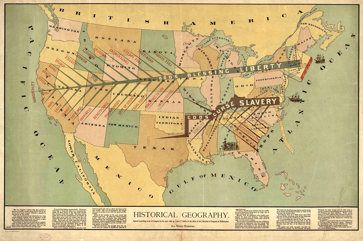
As our nation grapples with stark political divisions, a closer look at historical artifacts can offer unexpected insights. One example is John F. Smith's 1888 map "Historical Geography," a compelling piece of cartography that reflects the socio-political landscape of its time and resonates uncannily with today's national divide.
Smith, a relatively obscure cartographer, created a map in 1888 that depicted the United States not just in geographical terms but in cultural and political ones. This map was a vivid tableau of the regional tensions, economic disparities, and social divides that characterized post-Reconstruction America’s battle between good and evil.
Smith's map is visually dominated by two contrasting trees—one representing the New England colonies, “rooted in liberty and biblical virtues,” and the other representing the Southern slave colonies, “rooted in greed and exploitation.”
The tree of “liberty" originates in Plymouth and symbolized intelligence, sobriety, and moral righteousness.
The “tree” is rooted in the Bible and and extends “God’s Blessings of Liberty" across the northern United States - from “Free Schools” and “Intelligence” to “Joy, Light, Peace and Immortality.”
In stark contrast, the "God’s Curse of Slavery” tree originates in Jamestown, with a one dollar piece labeled “Mammon” symbolizing greed, corruption, and moral decay. “Avarice and Lust” lead to “Rebellion, Murder and War.” It ends in “Hades” - located in Texas.
Below the slave tree, “White supremacy” is propped up by the Dred Scott Decision, Fugitive Slave laws and other pro-slavery issues of the pre-Civil War era.
The sectional division is explained in the map’s caption:
In 1620, each colony planted a tree. The tree of Liberty, then quite small, was planted by the Pilgrims upon the Bible, at Plymouth, where it received God's blessing, which accounts for its wonderful growth and the excellent quality of its fruit.
The tree of slavery was brought from the old world and the people of Jamestown planted it upon mammon.
In time a dispute arose between the two colonies as to whose tree should grow so large that it would occupy all the land.
Slavery with its attendant evils would over-shadow the land with darkness, while Liberty with its manifold blessings would send a flood of light over the whole country.
At one time it appeared that the tree of Slavery would gain the supremacy, but God cursed that tree and it soon began to lean southward. Its friends then tried to prop it up, but it still contined to lean and showed signs that it would fall. This made the southern man jealous and he decided to murder his Northern brother, as Cain of old had done his brother Abel.
Smith's map was likely created to influence public opinion during the contentious 1888 presidential election. The map's depiction of the moral struggle between liberty and slavery mirrored the political battle between Republicans, who were seen as the party of federal authority and civil rights, and Democrats, who advocated for states' rights and the preservation of Southern traditions.
The closely divided electoral results of 1888, where Grover Cleveland won the popular vote but Benjamin Harrison secured the presidency through the Electoral College, echo today's political climate, where deep partisan divides often result in contested and polarizing elections. 1

Fast forward to today, and Smith's map feels eerily prescient. The divisions it showcased—economic disparity, cultural tensions, and political polarization—are still very much alive. Just as in 1888, we see a country where urban and rural areas often find themselves at odds, where economic inequality drives political dissent, and where cultural identities clash. The map's historical geography provides a lens through which to view our current struggles, offering both a reflection and a warning.
Since 1888, the political landscape of the United States has shifted dramatically. In the late 19th century, Republicans were “Lincoln’s party” of the North, advocating for federal authority and civil rights, while Democrats dominated the South, supporting states’ rights and segregation. Later in the 20th century, these regional allegiances swapped, largely due to LBJ’s civil rights legislation and changing economic policies. Today, the South tends to vote Republican, and the North often leans Democratic, reflecting a complete reversal from 1888.
More on America’s legacy of racism
White Supremacy on the Ballot (1866)
A racist 1866 political poster demonizes a newly freed African American as being idle "at the expense of the white man." Produced in support of Hiester Clymer, a racist and a 1866 candidate for the governor of Pennsylvania. He ran on a white supremacy.
How to Incite a White Riot (1898)
The Wilmington Massacre of 1898 (Nov 10, 1898) was a violent attack on the African American community in Wilmington, North Carolina, in which white supremacists overthrew the legitimately elected Fusionist biracial government in Wilmington and killed an unknown number of black residents.


And I should have mentioned that I always include a source link back to the archive where I found the material. This way, I've left plenty of rabbit holes for my readers to explore on their own.
A+