


The World Through Racist Eyes (1887)
Sample the classroom's colonial legacy

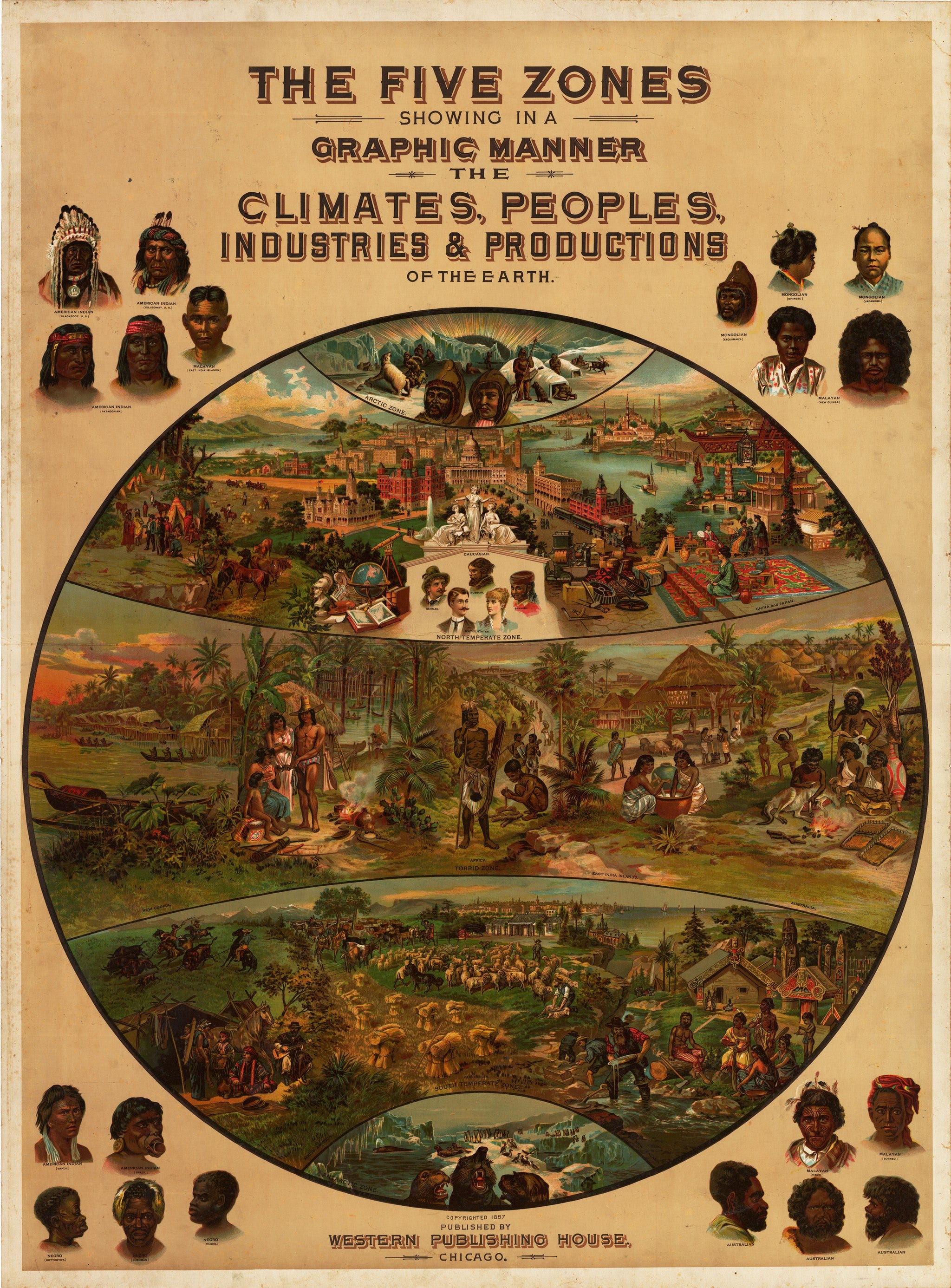
This pictorial poster reinforces racist tropes of the late 19th century with a schematic map of the earth’s five ‘zones’, with each zone bearing illustrations reflecting its characteristic climate, population, and economic activities.
It was created and published by Levi Walter Yaggy (1848 - 1912). Yaggy's large geographical charts are among the most beautiful and impressive educational charts published in the 19th century. Using chromolithography, Yaggy created stunning colors and contrasts in his images of the world, its regions, and peoples. Yaggy intended his charts to be used in classrooms by students, and issued a teacher’s handbook to assist with instruction.
The poster divides the world into five broad climatic zones ranging from frigid to temperate to torrid had first been done in ancient Greece and Yaggy employed the idea in his ambitious atlas.
Yaggy considered the northern and southern frigid zones to be inhospitable frozen wastes, the torrid zone around the equator as the appropriate climate for the world’s indigenous peoples, the northern temperate zone as the home of the world’s advanced civilizations and the southern temperate zone as the proper site for colonial settlement. Portraits of individuals of myriad races of indigenous peoples fill the spaces which otherwise would be void.
The Arctic Zone features Eskimos, polar bears, reindeer and igloos.
In the North Temperate Zone, the map is illustrated with easily recognizable iconic architectural edifices from magnificent palaces in China and Japan to Hagia Sophia in Istanbul, the Kremlin in Moscow, the White House in the USA. Also pictured in this zone is a group of marble statues under which is the heading ‘Caucasian’, and beneath the heading are featured five portraits labeled German, Spanish, Russian and United States (two portraits). In addition, in the northern zone Yaggy included a vignette which suggests scholarly and artistic pursuits including a globe, a telescope, several books, a marble bust and an easel replete with brushes and paints. The concentration of these edifices in this zone is evidence of his world view.
The Torrid Zone contains New Guinea, Brazil, Africa, the East Indian Islands and Australia and is peopled by indigenous peoples only, along with the housing and undertakings which occupy their lives.
The South Temperate Zone names South America, Australia and New Zealand. Here we see agriculture as practiced in Europe and the US, gold mining, vaqueros on the pampas and indigenous peoples with fancifully carved wooden trim adorning their homes. In the background is a vignette of a European-style city.
The Antarctic Zone is devoid of human habitation.
Levi Walter Yaggy (1848 - 1912) Was born in Plainfield Illinois to Jacob and Elizabeth Yaggy. He attended Northwestern College in Naperville, Illinois before moving to Chicago where he would found the Great Western Publishing House in 1874. He business would enjoy great success, ultimately expanding to include seventeen branch offices throughout the United States and employing thousands. Yaggy primarily focused on creating maps and educational books and portfolios for high schools and colleges.
Title: The Five Zones Showing in a Graphic Manner the Climates, Peoples, Industries and Productions of the Earth
Creator: Levi Walter Yaggy
Date: 1887 (Published) Chicago
Dimensions: 44 x 32.5 inches 111.8 cm x 82.6 cm)
Source: Wikimedia Commons
For more posts on the history of racial / cultural stereotyping try:

Now, through a more recent set of racist eyes, there are only three zones - Shithole Countries, Norway, and Us.