

The Illustration of the Graet European War (sic) (1914)
The Illustration of the Graet European War (sic) (1914)
When Russia was a very large and lethargic bear smoking a pipe

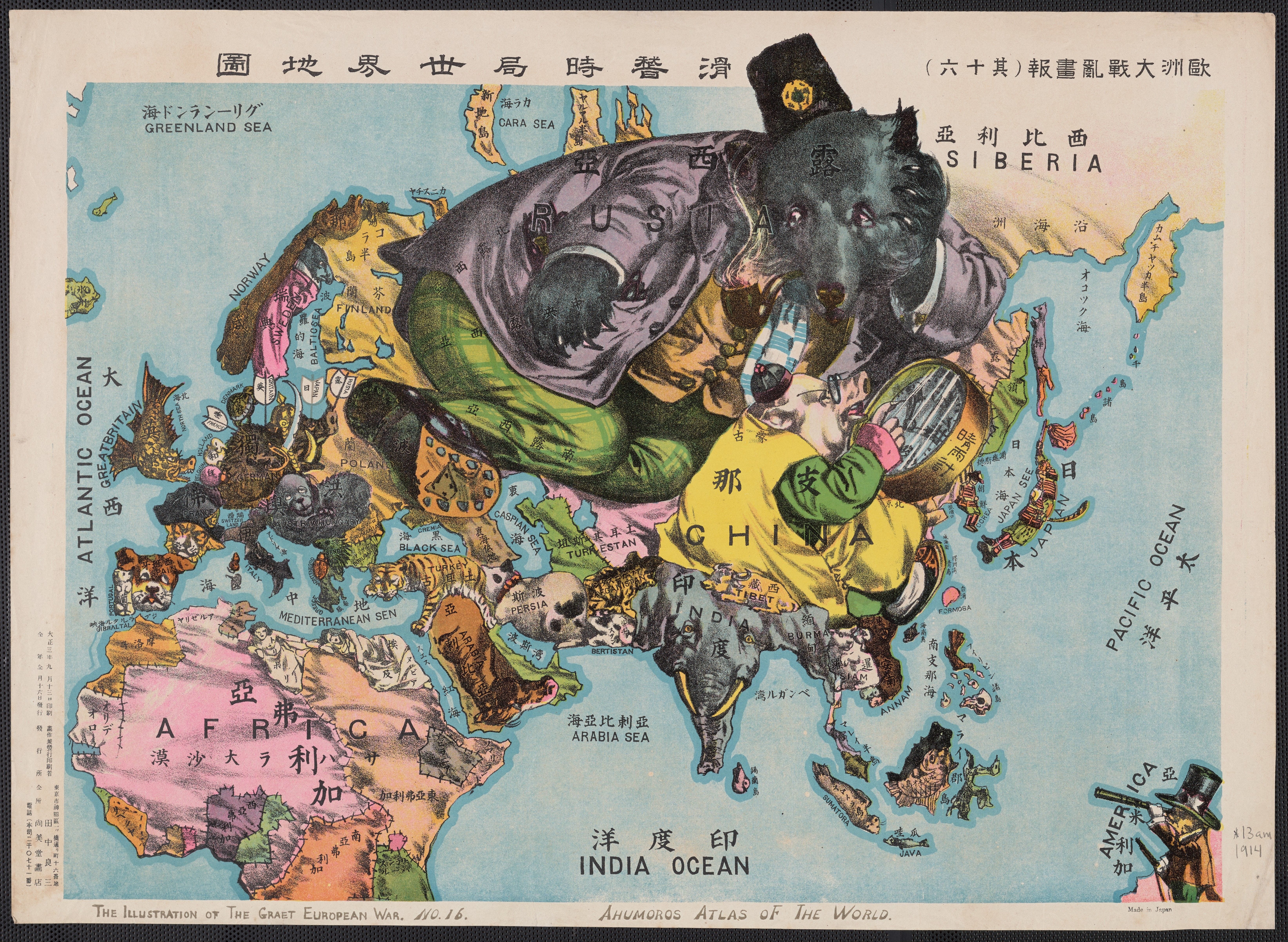
“Published just after the start of the First World War, on 13 September 1914, and subtitled in English ‘The Illustration of the Graet European War’ [sic], this map was designed and printed by Tanaka Ryōzō (1874-1946), who ran a print shop in central Tokyo and later became well known for producing prints of works by prominent modern woodblock artists.
Although it is described as ‘map of the world’, it is really a map of Europe, Asia and part of North Africa. The US is interestingly shown as a man in a top hat looking at Asia through a telescope from a small patch of land that appears to be somewhere in the middle of the Pacific. The rest of North and South America and all of Australia and New Zealand are missing.
The colourful and decorative map cleverly depicts each country as an animal, or more rarely as a human figure, giving an intriguing insight into Japanese perceptions of the state of the world (and some Japanese prejudices about neighbouring countries!) at the start of World War 1.
Under the terms of its alliance with Britain, Japan had joined the war on the side of the Allies, and its sense of Germany and Turkey as enemies is reflected in the depiction of Turkey as a tiger and of Germany as a wild boar wielding a sabre, which is being pierced by arrows labelled ‘France’, ‘Gritain’ [sic], ‘Japan’ and ‘Russia’. But the other main Central Power, the Austro-Hungarian Empire, is represented by a rather blurry image of dog, suggesting that perhaps the map’s illustrator had little clear impression of the nature of the Hapsburg Empire.
Meanwhile France seems to have been subsumed into the German boar, while Britain is a shachihoko – a mythical creature with the body of a carp and the head of a tiger, commonly used as a decoration on the roofs of Japanese buildings. (Ireland is either missing from the map, or is perhaps meant to be represented by one of the shachihoko’s fins).
The dominant figures on the map are Russia – depicted as a very large and lethargic bear smoking a pipe – and China – shown as pig which is rather enigmatically staring at a barometer. Both figures suggest powerlessness and inertia. India and Burma are joined together and represented as an elephant, while Arabia is depicted as a horse.
The only human images on the map are America, two languid female figures representing Nubia and Tripoli (i.e. Libya), and Japan and Korea. Japan is a large sword-wielding samurai, while Korea (which had been formally colonised by Japan four years earlier) is represented as a tiny unarmed figure sitting in a submissive position in front of the samurai. The map is labelled in both Japanese and English, with some rather charming mis-spellings in the English (‘humoros’ and ‘Japan See’ etc.) " (Asia Bookroom, 2022)
For contrast check out:

Title: The Illustration of the Graet (sic) European War. No. 16.
Alternative Title: Ahumoros (sic) Atlas of the World
Creator: Tanaka, Ryōzō
Published / Created: 1914
Publication Place: Japan
Repository: Beinecke Rare Book and Manuscript Library Call Number 13am 1914
I don't know about the rest of you but I'm going to Libya and wait out the war.